This summer, the Canadian seed company Maizex Seeds will implement a novel geographic information system (GIS) technique developed by the University of Guelph for counting plants in corn test plots in southern Ontario and Manitoba.
The solution was created by Dr. John Sulik, an Associate Professor in Plant Agriculture at U of G and a key member of the Food from Thought research team. The method enables Maizex to count young corn plants in drone images without using artificial intelligence (AI) — a novel use of existing technology that could replace traditional manual counting and more expensive unmanned aerial vehicle (UAV) options offered by industry providers.
“It’s been great,” said Shawn Winter, product development manager for corn at Maizex. “We’re working together to come up with a process that we can use to gather the information we need.”
Before turning to U of G and Food from Thought for a practical solution that would deliver the data it requires, Maizex spent five years working with a third-party company that tried to develop an AI-based plant-counting system.
The process was expensive and didn’t deliver the data Maizex needed; it was also an example of AI marketers targeting agriculture with glitzy, high-cost products that don’t effectively serve industry groups. Sulik’s approach is entirely producer-focused and is being delivered at a fraction of the cost of an AI system.
“In this situation, you do not need AI; you just don’t,” said Sulik. “This is a handcrafted feature, and in this era of deep learning and AI, doing such things are frowned upon because they’re not the most cutting edge — but you don’t need to be the most cutting edge.”
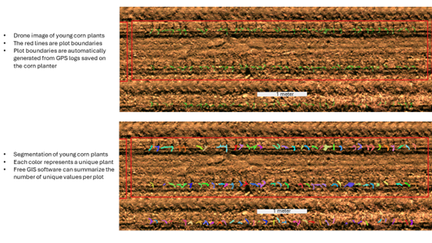
Sulik determined it’s possible to make a vegetation index from the wavebands of light in any camera mounted on a drone. Researchers take the ratio of green and red wavebands and separate all the pixels in an image into soil and plants on a histogram.
Then, they apply basic GIS techniques to segment the image and create an outline of each plant — making them simple and easy to count. With an accurate and efficient count, Maizex can make informed decisions about when to replant research trials, and to evaluate the robustness and overall effectiveness of new corn varieties.
“Here’s something that’s low cost, high throughput, that we can apply across our research program,” said Winter. “It sounds promising. If it works out in 2024, then we’ll implement it full-scale [across our operations] in 2025.”
If implemented at scale, the program would save tens of thousands of dollars each year in employee time and seasonal wages, because counting plants in drone images is vastly more efficient than counting each plot manually—and in some cases, that’s the only other way to generate accurate data.
Since the solution relies on inexpensive equipment and free software, the long-term plan is to create a tool for agricultural research and implement it at little or no cost, saving thousands of dollars per grower every year, in an industry with perpetually thin profit margins.
“You don’t need expensive cameras to resolve a plant in an image,” said Sulik. “You don’t need infrared wavebands to be able to distinguish plants from soil. A lot of people don’t get this because there’s marketing that persuades them otherwise.”
In many cases, AI marketers are selling products, not solutions. This partnership with U of G has the opposite approach, putting client needs first and producing meaningful results.
“It’s [saving] both time and money, so we can put those resources to other projects and use them more efficiently,” said Shawn Winter from Maizex. “John is always looking for what the end goal is, and how to get there at a reasonable cost third-party industry, just can’t seem to wrap their head around that.”
This research was undertaken thanks in part to funding from the Canada First Research Excellence Fund, with support from the Ontario Agri-Food Innovation Alliance, a collaboration between the Government of Ontario and the University of Guelph.